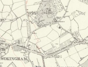
Click on this pic to go to this map. Slider in bottom left corner will show today’s layout. Reproduced by permission of the National Library of Scotland.
Arborfield historian Steve Bacon, sent a link to an incredible website which overlays old maps onto new ones !
The link zooms in on the Keephatch side of Wokingham; the overlay map is pre Great War. However, you can do exactly the same to any part of England and Scotland
On the bottom left corner there is a slider, just drag it left and the old map become transparent leaving the new one in its place.
What this one shows is just how much the A329M slices into the old countryside, but on the Wokingham side it is built up, but on the Bracknell side it is still green. You can look all over the UK. I’m sure if you go to the mining areas, you will see the reverse in action.
Many thanks to Steve.
Here is the link: https://shar.es/128zDh
Mike