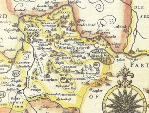
1661 John Speed map shows the importance of the River Loddon.
The area surrounding Wokingham is usually considered to have been a secluded region until the development of the road and rail networks. In this edition, Steve Bacon provides evidence that the area was in fact serviced by another transport medium: a navigable River Loddon.
As the years go by, the Borough’s roads groan under the onslaught of commuters, shoppers, lorries and delivery vans. Around a hundred years ago, it was the railways that carried most of the goods and longer distance passengers, while the roads were only used for the shorter trips. Some, such as Barkham Road, wouldn’t get a tarmac surface for many years afterwards.
Go back another hundred years, and apart from the turnpikes financed by tolls, roads were very poor and rutted. Progress was painfully slow. What did we do before the turnpikes? Where an area was blessed by rivers, our ancestors used them as much as they could. The Thames was a major highway – but it was restricted to the northern fringes around Remenham, Wargrave, Sonning and Earley. The market town of Wokingham was served only by the Emm Brook, surely too small for trading boats.
However, if you look at John Speed’s map of 1611, there’s another waterway given almost as much prominence as the Thames – the River Loddon, passing through Swallowfield, Arborfield, Winnersh and Twyford (or ‘Two Fords’). The old village centre of Arborfield was clustered around the river, while Swallowfield even has a ‘Barge Lane’.
300 years before that, Swallowfield was of national importance; here we now find the ruins of Beaumys Castle just off the A33, not far from the Loddon. The castle was replaced by Swallowfield Park, where the Blackwater River joined the Loddon. It was used by royalty, most notably by the wives of Henry VIII. How did they get to Swallowfield? It’s likely that the royal party came upstream from Windsor to Wargrave and then up the Loddon, disembarking at Kingsbridge near Barge Lane. The Queen’s Diamond Jubilee Barge gives us an idea of how they would have travelled.
The local historian Lady Constance Russell lived at Swallowfield House in late Victorian times, and wrote ‘Swallowfield and its Owners’ in 1901.This book (downloadable for free on the internet) gives plenty of information on the River Loddon. She describes how her husband’s ancestor remodelled the parkland as follows:
“Amongst other alterations, Sir Henry Russell filled up the canal which appears in the old prints of Swallowfield; it ran from the Lock Pool near the church to the Bow Bridge; and he also built the two bridges outside the park and the Church Lodge.”
A ‘Lock Pool’? This was no decorative canal – it was a short cut from the Blackwater to the Loddon, on three levels. The Swallowfield Enclosure Map (downloadable from the Web) clearly shows this waterway on three levels. There is evidence that the Blackwater was once much bigger than it is now, but it silted up and some of the water now flows into the River Wey further east.
There’s another Lock Pool further downstream on the Loddon, and is shown on the Arborfield Title Apportionment Map near to Arborfield Mill. The remains of the lock still exist, hidden on private land among the trees opposite the site of Arborfield Hall.
Another lock pool is evident near to Sindlesham Mill. The river flowed under Mill Lane at the hamlet of cottages known as ‘Brick Bridge’ on old maps, with a Boathouse nearby. The river crossing is now a metal bridge!
It’s difficult to imagine the Loddon as a navigable waterway now, but an old print shows quite clearly a large boat downstream of Loddon Bridge at Winnersh in 1849 when the new railway from Reading to Guildford opened. Well into the 20th Century, the George pub used to hire rowing boats here.
The Loddon is now much shallower than it was in Tudor times. In October 1972, disaster struck when the A329(M) was under construction. A partially built bridge collapsed into the river downstream of the railway bridge. Three workers were killed; many others were injured – and hundreds of tons of concrete poured into the river, helping to cause flooding in wet weather.
Recent legal opinion states that on rivers that once carried trading vessels, the right of navigation still exists. Will we ever see the River Loddon restored as a waterway? I doubt it!
Following his retirement from South West Trains, Steve Bacon recently moved to Royal Wootton Bassett where his house backs on to the Wilts & Berks Canal. We all wish Steve and his family all the very best in their new home.